 Last weekend, it was 90 kms of technical trail running with a 9 kg pack on my back.
This past weekend, it was a 5k road race (no PB, but there was a hill finish) followed by a recon of the Bunbury marathon course.
Both fantastic weekends, both at seemingly opposite ends of the running spectrum. I love the flexibility I have now without restricting myself to run "only" this or that kind of event or terrain. And I get to meet so many different people of different backgrounds this way, too. After the 5k, we were off to Bunbury, a scone in each hand! (How civilised it is to race and have a morning tea afterwards).
The Bunbury 50k course does look a bit flatter than the previous course, but I think there may be more sharp turns. Will just have to see how it's actually laid out on race day. It is a prettier course, I think, but I'm a fan of water. So the "3 Waters" name they've chosen makes sense. And it makes it dead easy to figure out how to paint my toe nails ;)
The recon will certainly help me over the next two weeks with my visualisation and other preparation. Projections have me very close to a 4 hr 50k (on track), which just happens to be Cdn W40 record time. It'll be a tough fight on the road that I'm not sure I can win, but it is a great goal to aim for. All things lining up on race day will matter - the temperature, wind, my hydration and fuel...there won't be any "extra" time to play with.
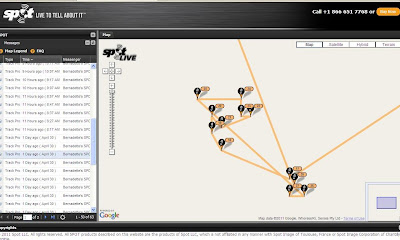
Last week, after my Bib run, I forgot to post something about the use of my SPOT device as a tracker. What it's supposed to do is send a message out every 10 minutes with your location. I had a look at the online log when I got home and there were a few very obvious gaps and anomalies. Some
 times it wouldn't get a signal out at the 10 min mark, so there would be a gap between two points and it would just draw a straight line between A and C. When I set my pack
  down at the end of the day on a picnic table, I got this:
I had left the unit on for perhaps an hour or two and it sent out all these slightly different coordinates that made it look like I was walking around in some sort of trance. In reality, the pack didn't move.
The next day, I mustered the necessary courage to run over Mundaring Weir (Yes, I still have that odd fear of dams, weirs, and submarines) and continued west towards Kalamunda for about 5 kms. However, the last point SPOT recorded was at Mundaring Weir. Certainly is important to appreciate that the technology on this unit isn't that crash hot. Better than nothing, but one might be looking for a while if a person's position can only be narrowed down to 25 sq kms.
No comments:
Post a Comment