Over the winter, I came across a mention of the
Via Valais in my Swiss trail magazine,
Die Alpen. It's a suggested 9 day "high route" for trail runners, akin to what skiers and hikers have. I was intrigued.
I've been running hiking "haute routes" in fastpacking style for years in the European alps. Presumably, this chosen route would be designed to be more running friendly in terms of grade than a "haute route" for hikers. As they wrote on their website, it would "traverse" in and out of valleys rather that go straight up and down.
Well, as I discovered, in the Valais region of French-speaking Switzerland, even a "traverse" often has a pretty steep grade! When you want to get from col or summit to the valley and up the other side, there's going to have to be elevation. "Runnable" is a very relative term! Let's dive in....
 |
| The faint green shows the route. Going west to east, you essentially valley hop. |
The route goes from a cable car station above Verbier to Zermatt over 9 stages. I decided to have my adventure end at the village of Randa - the end of Stage 7. I ran the trails from Randa into Zermatt last year. They are stellar - some of the best - with some of the best views. I didn't feel the need to do it again so soon. And Zermatt is a busy place. Seven days was enough for me.
 |
| Arcteryx 14ltr -added cords for more storage |
Then I considered how to compress two stages into one to give myself one very long day out in the middle somewhere. I'm not too good at sitting around huts and I like to challenge myself. I chose to combine Stages 3 and 4. By the end of Stage (Day) 1, however, I was a bit concerned about my idea!
It's always best to book your spot at a cabane (hut/refuge) in advance, which I'd done. Most only take cash. I had gpx courses loaded on my Garmin 920XT.
Day 1 (Stage 1): Les Ruinettes (~2200m) to Cabane D'Essertze (~2200m), advertised as 29km +/-1120m. I had a leisurely start and was at the top of the cable car at 10am with a good, stable forecast for a week. That's critical for this high alpine stuff and hard to find in summer! But going early in the season would require more gear and would pose more risks with lingering angled snow fields to cross. And some via ferrata (with ladders) might not be put in yet for the summer season if there's still a risk of avalanche onto it.
Given at least 7kg on my back, I figured the day would take me 6 - 7 hours with a nice lunch stop along the way. It was, indeed, 7 hours, but there was only a frantic inhaling of a torte myrtille (blueberry tart) and Schorle (sparkling apple juice) mid-afternoon. That took a matter of a few minutes. I was also "off trail" for a good 30 minutes of the day. I needed to learn that "wanderwegs" (sentiers/trails) often change each year, especially in glaciated areas. Winter snow and spring run off, with accompanying landslides, can dramatically alter a landscape, causing trails to be rerouted through an area. I reached the first of such places about 3 hours into my day and spent over 20 minutes having left the marked red-and-white trail, following my gpx, which was trying to have me cross a very fast flowing glacial run-off. After a few attempts at starting across, and then trying numerous other places to ford the dangerous water, I finally turned back to try following the red-and-white markers. Sure enough, they went all the way around the outside of this area and then reconnected with the gpx route on the other side. First lesson learned. I was much better prepared later in the day when I came to a landslide. My gpx said go straight on, but I noted the red-and-white blazes on the rocks had me turning left. I started following the gpx - with my radar on alert this time - only to realise there had been a huge landslide and the trail was rerouted this year to pass below it.
A savvy trail runner in these parts needs to appreciate this aspect of running with gpx files - maintain situational awareness, understand the lay of the land and why routes might need to vary after a hard winter/spring. My 30k day was in fact 33k. My average pace was thus 12.50min/k (I don't stop my watch when I pee, eat, etc - this helps me appreciate the reality of timing for future runs.)
 |
| A "trail" on Stage 1, headed for Col de Louvie at 2921m. Boulder fields are also very slow, but there's a reward coming! |
Much of Stage 1's "claim to fame" is supposed to be running on "bisse" trails - "old irrigation ditches that tend to be silky smooth for running" according to the website. A half truth. Every bisse trail I can recall was super narrow, with small trippy rocks, and also sometimes 'grooved' out in a trench. They were annoyingly slow for running. I passed a couple of Alaskan/Seattle American trail runners on a snow descent section and met them later at the hut. They said they had been "crushed" by the stage.
 |
| Reward for reaching a col - stunning new views and snow descent! Below is where I tried to cross the raging torrent. |
The hut at day's end was run privately by a mixed French-Canadian/Swiss-French family. They were incredibly welcoming, organised, relaxed but efficient, and really sought to give me vegan options for dinner, breakfast, and my take-away "pique-nique" the next morning. Their prices were the best, as well. They have a road up to their place, which means they aren't paying a helicopter to deliver supplies and remove waste. And their water was potable - a bonus in not having to get out the water filter. They even discounted my picnic because I didn't take the usual meat and cheese! I made almond butter and jam sandwiches (I brought 3 sachets of almond butter for this purpose.)
 |
| Cabane D'Essertze |
Day 2 (Stage 2): Cabane D'Essertze (~2200m) to Cabane Aiguille Rouge (~2800m), advertised as ~30km + 1800m - 1200m. Putting on my shoes outside the hut at 8am, I chatted briefly to two German (or Swiss-German?) girls who had also run the first stage the day before. They decided the days seemed far too much for them and were going to start adjusting them to suit, starting by breaking Stage 2 in half. I never saw them again.
This stage was much more runnable than Stage 1, however, and I was done in 6.5 hours. A 12:12min/k average. But there was still no lingering lunch stop. I clocked 31.5k + 1545m - 1000m. A key feature of this day was the Pas de Chevres (Pass of the Goats). It involved a set of 4 connected ladders, which you reach via a scramble over a moraine with some giant boulders. Awesome slightly scary fun.
 |
| Enroute to becoming a goat. |
An unfortunate aspect of cols/passes/saddles is that everyone has the same idea - stop at the top for summit sandwiches :) This is an unfortunate thing for me, as an introvert. This section was also shared with a Cicerone guide book "haute route" for hikers. I thought I'd landed in England at the top and heard the word "bollocks" far too many times in a minute - and there were no goats involved ;) I decided I'd enjoy my summit sandwich without having to hear people discussing whether they could get mobile reception or not, so I headed downhill.
Cabane Aiguille Rouge is also privately owned (i.e., not a Swiss Alpine Club/SAC hut). I've met gruff and grumbly hut wardens before, but he was one of the best. It was not a nice atmosphere inside for any of the guests. There was an air of silence inside, uncommon in most huts. I was on the trail by 7.40am the next day, after one of the worst breakfasts possible at a hut. Not a place to hang out. The American trail runners had come in two hours after me. I write that not to boast, but to try to make it very clear that this route is TOUGH. They were also jetlagged, which wasn't helping them.
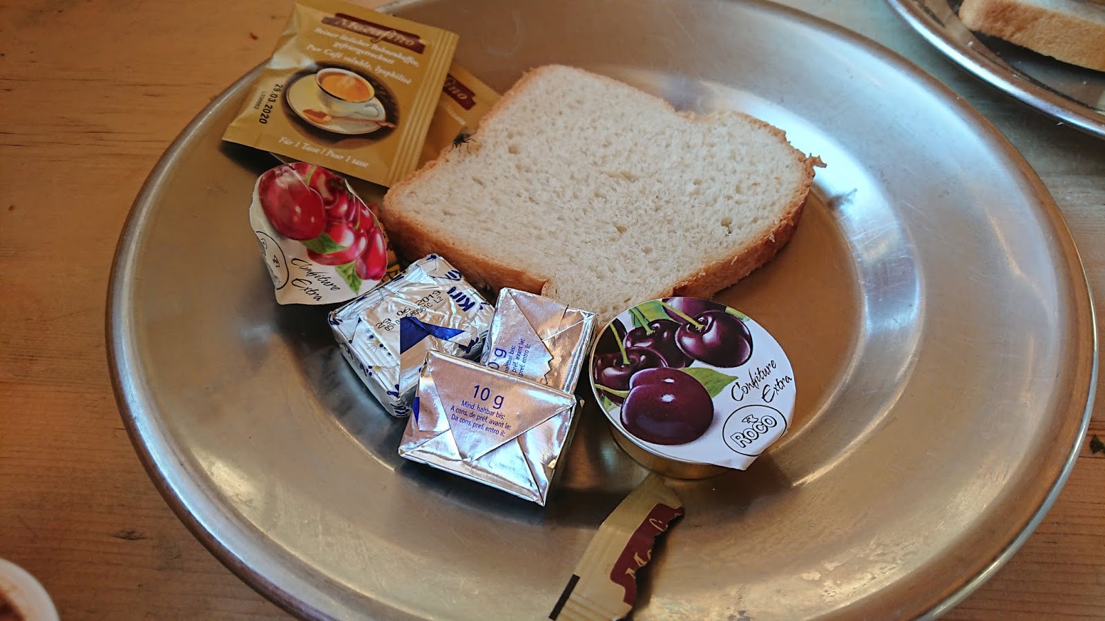
 |
| Stale white bread, usually restricted to the highest alpine huts. Jam, butter, instant coffee, 1 tea, and 1 choco-sugar drink. |
Day 3 (Stage 3 and 4 combined, minus a few km): Cabane Aiguille Rouge (~2800m) to Cabane Becs de Bosson (~3000m) 25km + 2220m - 2050m and Cabane Becs de Bosson to Cabane De Moiry (~2825m) 17km + 870m - 1025m.
I had decided on a long day, combining these two stages. However, given the average pace seemed to be over 12min/k, I realised this long day could very well be 10 hours. Thus, by looking at the maps, I noted that I could get to within 2km of the Becs de Bosson hut, but skip it. I went through the same terrain, but stayed just below the hut, cutting off roughly 2km from each stage, so 4km in total. I was really happy with my choice.
 |
| Leaving Aiguille Rouge starts with a bit of great moraine before the steep drop around the bend to the right. |
The day started with a super long, steep descent from Aiguille Rouge. I couldn't afford to smash my shins up by letting loose. This wasn't a one day outing. My legs were feeling the vert of two days and jostling down the gnarly track with the big pack on my back didn't help my pace any! It was over 11min/k. We were in the middle of a heat wave. I was starting each day in a short sleeve t-shirt, even from 2900m! Arriving at the valley floor in the lovely historical little village of Evolene had me racing around filling my arms with fruit and cold beverages. It was apricot season. I'm sure I smelled and looked like a wild animal.
From the low point of 1371m, I had to climb back out towards the Pas de Lona at 2787m, under the Cabane Becs de Bosson. It was during this climb towards the Becs de Bosson that I made a right at a fork in order to skip the hut. I felt an initial sense of unease at not having a gpx track on my watch anymore, but that was quickly followed by a feeling of total relaxation and freedom. Suddenly, I didn't have a "route" that I "had" to follow anymore. I could pick and choose where, when, and how to go. Total freedom! Not following anyone else's rules - woohoo! I immediately realised how odd it was that I had felt a subconscious pressure to do the exact "correct" route given by the Via Valais team online. But, really, who cares? Why? I've always made up my routes in the past for fastpacking and loved them. I've been able to be flexible to change as I went along. I had unwittingly made a rule in my head that said if I didn't follow their route, I was somehow "slack" or "wrong." Whose adventure was this, anyway? :)
 |
| Lac de Lona from near the pass. Headed into the valley ahead where Lac de Moiry is. |
Arriving at Pas de Lona, I gave a nod to the cabane above to my left and joined the gpx track for Stage 4. The landscape changed on the high plateau and the colours were fantastic. I enjoyed a long runnable descent past Lac de Lona, then a short climb to a col next to Sex de Marinda (sex means rock), and another long descent to Lac de Moiry (a dam). After a flat run alongside the lake, I had the last climb along a moraine, then a bit of via ferrata and some slightly precarious sloped snow crossings to get to Cabane de Moiry. In 8.5 hours I covered ~41km +/- 2540m. Average pace 12.31. There's a theme here.
 |
| A pleasant run along Lac de Moiry, headed for the cabane, which is above left of that "black hole" in the glacier ahead. |
I had my first chance for a shower (most huts don't have the option), so paid the 5CHF for 5 minutes. I got out and my feet still stunk. Shower fail. Despite being right beside a huge glacier at 2825m, it was so hot! My evening attire (i.e., my only set of clean clothes) was long johns and it was too hot for those, so I had to put my CEP running shorts back on for the evening. No trail runners sighted, but climbers were here to do the surrounding peaks.
Each stage has a suggested "bonus peak." I hadn't done any thus far and was keen on Pigne de la Le (3396m), the peak behind the cabane. It was listed on Via Valais' website as "easy ridge scrambling." The two climbers I met at the hut during dinner talked me out of it. I know the ease of routes changes depending on time of year and conditions and everyone has a different risk/comfort level, but based on what they said, it sounded like Type 3 fun. Especially being alone.
 |
| My view for the evening, with the "black hole" in the glacier now below me. |
Day 4 (Stage 5): Cabane de Moiry (~2825m) to Zinal (~1600m). Advertised as 24km + 1064m - 2215m. Breakfast at this cabane was offered between 5.30am and 7.30am. No one's sleeping in there. After leaving the cabane, I traversed and climbed up to Col de Sorebois (2850m). Sweat was dripping off me and it wasn't even 10am. At the pass, the next valley appeared below - Val d'Anniviers, with Zinal as the destination. There's a handy-dandy cable car right there, ready to take people down. And the cabane even offered a free pass for the cable car with every stay! (A special promotion being done by the Val d'Anniviers communities this year.) But I was in no hurry to get to Zinal and couldn't bear the thought of missing my promised "incredible views of Zinalrothorn, Weisshorn, and Dent Blanche." I was committed to doing the long traverse into town instead. I did enjoy an espresso at the cable car station first.
And a long traverse it was! It went up before it went down, there were lots of narrow bits, and when it did finally go down, my right shin let me know it was getting tired of all these shenanigans. The waterfall was the highlight and welcome in the heat. I spent some time setting up a selfie photo and didn't mind all the water spray at all. The last section of downhill was another super steep bit, with water in the area, causing vegetation to thrive. Much of the trail was overgrown and it was hard to see my footing. Nettles are a real pain for me, as I react really badly, so that added to my challenge in that section. I felt like I was trying to run in an overgrown ditch.
 |
| Highlight of traverse: crossing a waterfall - the rope was prudent, given the water flowing over the rocks under foot. |
Surprisingly, my Garmin actually agreed with the distance advertised. I got 24km, but with slight variations in vert (+890m - 1980m), and I was out there 5.25 hours, which included for the first time a proper 15 minute sit-down picnic at Sorebois. Average pace was therefore 13min/k. There's so much terrain in this route that I sure wouldn't want to be on in the rain or in a whiteout (as when you are in a cloud with near zero visibility). There are tons of narrow sections along ridges, which would get slick from mud in the wet. The rocks would also become treacherous at these times. Boulder fields are nasty in rain - I've been there before! In some plateaus and boulder fields, markings (blazes on rocks) would be impossible to see in low visibility (as in a storm). Route finding would be near impossible at such times (been there before, too!)
 |
| In case you don't believe the sign warning of land/rockslides, mother nature brings the point home more clearly. |
I stayed in a great room in Zinal with a shower (no toilet). I literally walked into my room, took off my shoes and pack, and stepped into the shower with all my running gear on. It was too hot for the long johns again, but damp clean running shorts on a hot day were welcome. I ate a smashed avocado and kidney beans over a bag of rocket (arugula), with my little turmeric stash as anti-inflammatory enhancing flavouring.
Day 5 (Stage 6): Zinal (~1600m) to Turtmann hut (~2520m). Advertised as 19km + 1687m - 841m. More up than down, to balance out the day before. I got an 8.30am start and was in a t-shirt as usual. Not once in the six days did I wear my lightweight Montane rain jacket, though I did use my Arcteryx synthetic midweight jacket a few evenings. Not to say my rain jacket wasn't handy - wrapped around the makeshift webbing on my pack, I would fill the sleeves with my daily picnic, as I had no more room to stash a sandwich, fruit, and carrots.
The bonus summit for stage 6 is L'Omen Roso, at 3031m, accessed from the Col de la Forcletta. Heading up to the col, I passed two single trail runners - a first. This section out of Zinal is the end of the Sierre-Zinal 31km mountain race held each August. Neither trail runner had a pack or other visible gear with them.
Thunderstorms were now forecast as a possibility for the next two afternoons. Once I got to the col and could assess the weather in 360 degree view, I decided to do the quick bonus summit. I scrambled to 3042m. In the distance, I could see a lower prominence, but the distance I'd travelled and the altitude told me this should be the peak. At least it was the highest point :) Later, I discovered that L'Omen Roso is indeed slightly lower than the prominence I stopped at. How odd!
 |
| From L'Omen Roso (actually P.2042), I see the Schollijoch (tomorrow's pass). Below that, Turtmann hut. |
I descended into the Turtmann valley. Crossing the pass was the unofficial border between French and Swiss-German speaking regions. Valais was now called Wallis. A valley was now a tal (Turtmanntal) rather than a val (like Val d'Anniviers). They call this 'border' the Rostigraben - Rosti is a Swiss-German potato pancake made from grated potatoes. Graben is a burrow or ditch.
I finished the day with 20.5k + 1705m - 930m. So almost bang-on for distance and vert, given I did the bonus peak. Average pace was 15.29min/k - slower for the scramble summit and taking a bit more time in the day generally, knowing it was short.
 |
| Another dam. Turtmann hut sits above and behind, centre photo, as a black dot on the ledge. Glacier behind it. |
Arriving at the hut, I reminded the hut warden that I was vegan (it was in my reservation, but if they forget, it gets stressful at dinner time when they're trying to feed a heap of people at once). This year I have found a stunning difference at the huts - they all seem to be suddenly catering for vegans, at least in a basic way. In prior years, it's been a real struggle. Requesting simply "rice or potatoes" often made hut guardians upset; I think it was because they pride themselves on good meals. They want to provide something lovely - it would embarrass them to serve a plate of plain potatoes. I was shocked by the Turtmann guardian's reply. "In my heart, I am vegan, too. But being here.... You are the second one today."
I then went through my usual routine. Most hikers, I notice, collapse onto the nearest bench outside on arrival, cold beer in hand. Me? I prefer to do my chores, then relax. So, first, I have my Hammer protein recovery powder and my "Race Cap Supreme" which seems to keep my restless legs at bay. Then I like to wash, whilst I'm still as warm as possible. Standing half naked at a sink rubbing freezing cold mountain water on my skin is a mixed emotion experience. It's also a really slow process compared to a shower. Once the washing is done and I'm in my "hut clothes," I go about filtering my water for the next day, unloading any rubbish, shifting things as need be to have the pack more ready for morning. Filtering water can save 10-15CHF per day. And it saves several sea turtles, I reckon, by reducing my plastic bottle consumption. I get my "hutten schlafsack" out - a silk sleeping bag liner - and lay it on my chosen (or assigned) bed in the dorm. One must sleep in a liner for hygiene reasons. The pillows and duvets provided at the huts are only washed once a season, I believe. Once the chores are done, I go order lots of hot and/or cold drinks and enjoy the views outside. At Turtmann hut, I wanted it all - I ordered a schwarztee (black tea), a Schorle, and a bottle of sparkling water to dilute the Schorle even more. So much for the turtles :(
 |
| Just below Turtmann hut. Another insanely gorgeous place to spend a night. |
A weak thunderstorm came through about 4.30pm. Thunderstorms were forecast as a threat all day for the following day, which was slightly stressful, given I was going to do the biggest pass and the biggest via ferrata onto a glacier the next day. I reminded myself that I'd just have to roll with the conditions and be willing to turn back and run out Turtmann valley instead of via the glacier towards Zermatt, if that was required.
I was initially worried at dinner when others got cream soup and I got parsley bouillon. Then others got green salad with cream and fatty pork slices and I got the greens with vinegar. Not many calories for me.... But the main made up for it - all the couscous I could eat, along with a huge bowl of mixed veg in a thick tomato base. For the first time, I went to bed not hungry.
Day 6 (Stage 7): Turtmann hut (~2520m) to Randa (~1500m), 18k + 1376m - 2453m. Another massive downhill day. The bonus peak is Ussers Barrhorn, typically just called Barrhorn. It stands at 3610m and is considered the highest "hikeable" peak in Switzerland. I did it last year, running from Turtmann valley past the hut to the summit, then back in a day.
This time I'm to go to the col (joch in German), called Schollijoch. From there, I descend a series of vertical and horizontal ladders and scramble with the help of iron rungs and ropes and cable down to Scholli glacier. No crevasses. I've been carrying my kahtoola microspikes for this day. There have been many snow fields to cross over the past 5 days, but by kick-stepping and having big 8mm lugs on my Inov-8 x-talon 212 shoes, plus poles, I felt safe to traverse each one without the kahtoolas. The first bit of glacier near the rock wall is quite steep from images I've seen. The Via Valais team don't mention that, but especially being alone and in such a "crux" section of the route (so awkward to go back and find another way out of this area, without it being over 20km), I was comforted having the kahtoolas.
 |
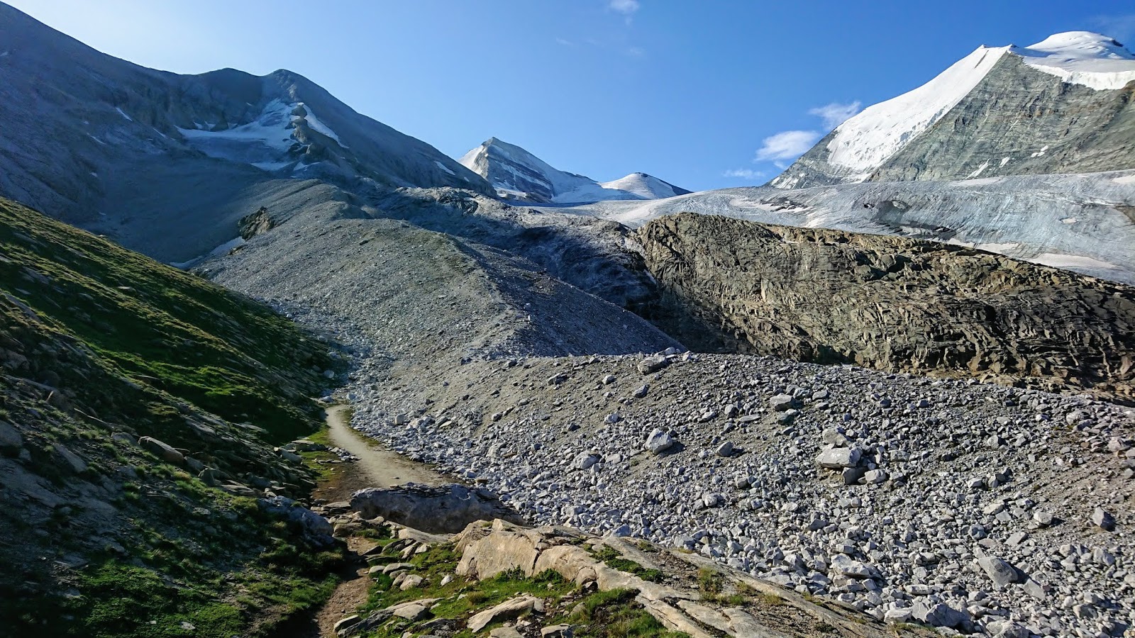
| Another moraine climb towards Schollijoch, blissfully alone except for a marmot. |
On the trail to the summit of the "joch", I was surprised to be alone. I knew two Dutch men had started around 6am, worried for the weather, perhaps. They were going out and back. I started at 8am. At the col/joch, I looked left up to Barrhorn and could see a few outlines of people. To the right was Schollihorn. Last year I'd seen people scramble the first part of this. I was intrigued and there were no storms imminent. I headed up.
It was quite an easy summit, with just a little scrambling and then a big, broad plateau.
 |
| On the lip of Schollihorn, 3500m. Brunegghorn left and Bishorn right, behind me. |
Back at the joch, I got out my coveted Hammer gels, which I had been saving for 'emergencies.' I figured a good hit of chocolaty carbs was just what I needed to brave this descent. Last year when I'd glimpsed the edge of this "trail", I'd only been able to hold my camera in front of me. I couldn't even look down. But after the past 5 days of gnarly, exposed terrain, I was almost unfazed. I definitely took my time, but the descent was fine. It was indeed steep stepping onto the glacier and the snow was still glazed over from melt and refreezing overnight. I was very glad for the spikes. Even more so at the far end of the glacier where it becomes thin ice hidden under loose rock. That's like trying to walk on marbles on a marble floor. I don't envy anyone without spikes in that bit.
 |
| The start of the via ferrata at Schollijoch down to the Scholli glacier. I saw this last year and it scared me! |
At the end of the glacier, I stopped for first lunch. The sky still looked good. But then I realised I was still at 3150m! There was a lot of descending in slow terrain still to be done. Fortunately, the grey clouds swirled around, but never developed into anything sinister, as I had a long way down with a lot of exposure.
 |
| See the blue ladder way up there? |
Overall, I took loads of time, given it was my last day and I could mostly keep an eye on what the clouds were doing around me. But it's definitely a long slow descent with lots of traversing, so I'd caution everyone to watch the clouds in all directions vigilantly.
I stopped in the shade on the never-ending descent, once I finally got out of the exposed high alpine and just enjoyed my environment - the quiet and solitude. I had luckily found out that the suggested gpx route to Randa (part of the long traverse) was closed due to concerns for landslides coming from a melting glacier above the trail, so I had to descend more directly down into another village. Once at the bottom, I aimed for the only shop - a Denner Express - and bought a giant punnet of raspberries and an icy pole as the Aussies call it (a popsicle-type thing). It was at least 30 degrees. There was no way I was going to run the exposed river valley down to Randa. I wasn't carrying on any further. I sat in the shade and waited for Rolf to come a few hours later, once he was done his own adventure. 6 hours, 18.5km + 1085m - 2260m.
Take home messages: This is a tough but gorgeous route. The glaciers and moraines are incredible. I would not call it a "sweet single track" route - for that, I'd go to the Dolomites or another region. It demands good weather, a head for heights, alpine experience, and a willingness to turn back in the wrong conditions. A few sections could be re-worked, I think, to make a more runnable route. But if you come to terms with what it is and just go with the flow, accepting all the long traverses that undulate or actually go up before going down, you'll be at peace. If you have the Swiss online mapping system on your phone, you can more readily come up with alternates to your route to make it more enjoyable if the days get too long.
Gear: The Via Valais website offers some good photos and list of their favourite and suggested gear. Mine included:
 |
| Pack looked small and felt huge! |
- Arcteryx 14 litre pack with extra rigged bungies for storing my rain jacket (which then stored my picnic for each day). Several small carabiner-type clips for attaching things to bungies/pack
- Montane very light rain/wind jacket with a pair of light Icebreaker gloves in the pocket (gloves never worn - highly unusual heat wave!)
- CEP arm warmers (worn one morning for 5 minutes, but used extensively - my pack would rub my back when the water ran low, so I was able to use the arm warmers to create cushioning)
- Montane prism gloves (warmer weight in case of cold, inclement weather - not used)
- Raidlight super thin rain pants (not used, but glad I had them)
- Arcteryx Atom LT hoody (midweight synthetic - the best ever - used in Arctic, dries fast)
- Leki poles
- 10,000mAh battery pack, USB-C cable for phone, AC adapter for USB, Garmin charging cable
- Petzl e-lyte (teeny torch for getting to toilet at night without blinding everyone
- Sea to Summit eye mask, ear plugs, mini toothbrush and paste, sunscreen, chapstick
- Quick dry towel, small soap, nail file, 2 elastic hair ties
- Cash (budget 100CHF/day to ensure plenty), passport, bank/credit card, SAC membership card
- Delorme Inreach satellite tracker/SOS device
- Sea to Summit silk sleeping bag liner (stuffed in bottom of pack - not in a stuff sack of its own)
- Fixomul for preventative taping of toes, folding scissors, folding knife, Compeeds (just in case)
- single sachets of 2Toms Sport Shield anti-chafe
- Mini-Sawyer water filter in a thin Sea to Summit bag
- First aid kit (gauze, pads, tape, antihistamine, painkillers, antiseptic solution)
- Android phone with Fatmap app, MeteoSwiss app, Swiss Wanderweg map app
- Hammer Nutrition protein recovery powder and Race Caps, cinnamon and chia seeds, turmeric
- A small paper novel (my token luxury!), a pencil, a few sheets of paper route notes
- a real paper Swiss 1:50,000 map of the 2nd half of the route
- kahtoola microspikes in a Petzl crampon bag to prevent punctures
- A few Ziplocs, reused many times over for snacks/sandwiches each day
- Collapsible Perth Trail Series silicone cup (turned out it was only used for my protein mix)
- Daily snacks (often a sandwich, peanuts, various bars, dried mango, chocolate covered coffee beans)
- Evening hut wear (kept in a compressible Sea to Summit bag with my dry towel and jacket):
- A clean Odlo sports bra, thin running/tech t-shirt, Montane primino 'boy short' undies, and long johns, clean Injinji socks
- Daily wear (same for 6 days):
- CEP 2-in-1 shorts
- CEP calf guards
- Injinji socks and Dirty Girl gaiters
- Inov-8 x-talon 212s
- Odlo sports bra
- Montane primino shirt (these shirts don't smell - awesome choice for multi-day)
- Montane primino 'boy short' undies
- Garmin Forerunner 920XT with all stages loaded as courses
- Julbo Aerolite "Zebra light" sunglasses (best I've ever owned and won't go back now)
- tubie (buff-like product mainly for nose-blowing)
- thin headband (worn around my neck a lot to reduce sun, but handy to put over the cap on windy ridges)
- white "Udo's Oil" cap
 |
| Last day shady stop. Carrying the flip flops I paid 15CHF for. |
Purchased in Zinal:
- shoe powder to try to de-stink my runners (left the rest in hotel)
- flip flops so I could walk around town without having to wear my running shoes. I then strapped them to the outside of my pack for the last two days and didn't have to wear the hut "crocs" at Turtmann hut.
 |
| Happy traveller on a moraine. Ready to go again! |
 The race organisers have obviously seen too many runners screaming with calf cramps, so they aimed to beat it with their fleet of people doing calf massages just after the finish line! My left calf looked like it had a worm in it the way it pulsed. After that, the priorities were water, shade, more water, and slow walking to ease the calves back into complacency. I found my drop bag and dug out my phone. Best day ever. Phone was fine. I took it off aeroplane mode and set out to check online results.


 The race organisers have obviously seen too many runners screaming with calf cramps, so they aimed to beat it with their fleet of people doing calf massages just after the finish line! My left calf looked like it had a worm in it the way it pulsed. After that, the priorities were water, shade, more water, and slow walking to ease the calves back into complacency. I found my drop bag and dug out my phone. Best day ever. Phone was fine. I took it off aeroplane mode and set out to check online results.